Friday, April 30, 2010

Kent's Ledge - South Royalton

Quick Facts:
Moderate incline, estimated 2-3 mi round trip, estimated 1300ft summit elevation.

Highlights:
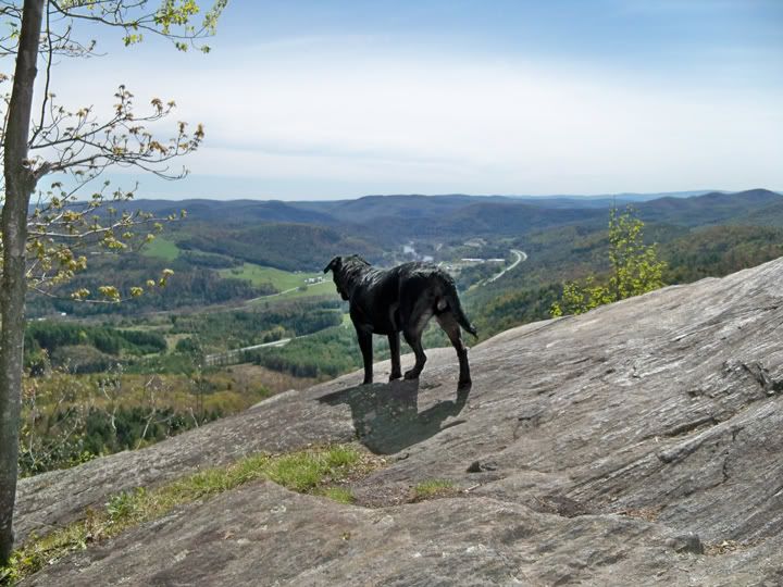
Summit views, ledges to explore, pond and other trails nearby.

Directions:
Park in the town of South Royalton by the green. The post office, which faces the green and looks like an old train station, is a good place to start. Facing the post office from the green and looking to your right, you'll see a red cement-brick building across the tracks called the Crossroads Bar and Grill.

Cross the train tracks so you're in the dirt parking lot of the Crossroads. Walk around to the other side of it and in the corner of the lot to your right is a small footpath (and a few beams as a bridge across a small stream) that will take you up to Rainbow Street, which is a dirt road with a few houses on it. Take a right onto Rainbow Street and follow it up until you reach the metal gate. There are signs all over the place regarding authorized vehicles, no dogs, etc., just ignore them (I actually talked to some folks in town and their response to the signs were exactly that!). I brought three dogs and kept them on a leash until we were well past the gate and nobody seemed to mind.

Past the gate, there are a few municipal/mechanical buildings and beyond those is a tunnel which goes under I-89. There is a chained gate, but also plenty of room for an adult with a backpack to get through. I believe they only chain this off so that no one goes 4-wheeling up there!

Once through the tunnel, just follow the overgrown road, bypassing a small footpath to the left, until you reach the big pond. The trail goes off to the left or right here, and I decided to leave the right-side trail for another day/blog, so stay left and go up into the woods to get to Kent's Ledge! Once in the woods, just keep going up the overgrown road, which turns into more of a "trail" as you keep going.

Details:
It's a pretty consistent incline most of the way, but nothing too strenuous. In the spring it will probably be pretty wet and mucky, so if you're going during that season, I'd suggest boots. If you're a sneaker-hiker, maybe wait until June or July for this one.

It only took the dogs and me about half an hour to get to the summit, which is beautiful and has some sweet views. We explored around the top for awhile and had a snack before descending back to the town green. All in all, the outing was about 2 hours long (including a quick game of fetch by the pond on the way back).

Wednesday, April 28, 2010

Cotton Brook Loop - Waterbury Center

Quick Facts:
Gentle incline, 9.9 mi loop, 1571 ft summit elevation.

Highlights:
Bridges & rushing waters, Waterbury Reservoir campsite, old apple orchards.

Directions:
Take I-89 to the route 100 N exit (Waterbury/Stowe). Off the exit, head north towards Stowe on 100 N for about 7 miles. Take a left onto Moscow Road and follow for about 2 miles. Then take the left onto Cottonbrook Road, although it may be unmarked (if you were to continue on Moscow Road to the right, it becomes Nebraska Valley Road). In .5 miles, park near the red metal gate on the right.

Details:
Start up the dirt road after the red gate and continue on the road until you reach a wood shed. There will be offshoots on the road which are tempting; they're all bike/snowmobile trails and end up leading back to the road at some point or another, so feel free to get a more hyped warm-up by taking them. Just make sure you get back to the road...


At the wood shed, stay right on the road. You'll come across an old apple orchard with a stone cellar hole nearby worth a checking out. Continue on the road over wooden bridges and rushing brooks. At 44.437218°, -72.805298° is the trail high point, from here on out its mostly flat or downhill.


After awhile you'll come to a sign with arrows and what looks like road signs all over it - its very odd and I've never seen a trail marker like this before - you'll know when you see it. Take a right down onto the marked bike trail at the sign. It may not be marked right at the trail head, but a little venture inwards and you'll see signs on the trees that it is indeed a bike trail.


After the zig-zagging descent, the trail comes to a Y and you get a close up with Cotton Brook (its pretty rapid in the Spring) - cross over the bridge to your right and continue until you see the Y at another old apple orchard. Go right and pass through the orchard...expect to see fairies and elves, its a pretty magical-looking place!


The trail is a footpath now and it'll take you right to one of the most beautiful campsites I've ever seen - right on the Waterbury reservoir. This a great picnic spot and a climax to the monotony of the first 7 or so miles of this hike. Follow the footpath to the north along the reservoir's banks, but beware the trail does fade in and out. Best bet is to stay along the banks until the canoe launch, then hop on the dirt road north and walk .3 miles back to the red metal gate. But, if you still have the energy left to go gallivanting, look for the ridge that will allow you to survey the north end of the reservoir and get up to it by bushwhacking. There's a trail up there that will lead you back to the dirt road through some of those bike trails I mentioned before - Then just retrace your steps along the road back to the red metal gate.

Tuesday, April 27, 2010

Joseph Smith Birthplace in South Royalton, Vermont - Patriarch Trail

Quick Facts:
Moderate incline, 1.6 mi round trip, 1440 ft summit elevation.

Highlights:
Winnie the Pooh "Honey Bear Tree", sitting benches aplenty, perfect picnic spot at the summit!

Directions:
From I-89 heading south: Take exit 3 (Bethel) and take a left onto Route 107 towards Royalton. At Eaton's Sugarhouse, take a right onto Route 14. Go through Royalton and into South Royalton - once you pass through the intersection for 110, Dairy Hill Road will be on the left about a mile down Route 14. On Dairy Hill Road, travel up the hill about 2-2.5 miles to a big sign for Camp Joseph on the right. Although it's the entrance to the Memorial, it's also technically "LDS Lane". Drive about 1/4 mile until you see signs for parking, and a gravel lot to the left where you can park. Out of the lot, walk left until you see the memorial. There is a small road to the left of the memorial that leads into the woods, follow that all the way to the end until you see a small sign for the Patriarch Trail - there is a restroom building at the trailhead as well.

Details:
If it weren't for the groundskeepers at Camp Joseph referring to this little gem of a trail as a "challenge", I probably would have written it off completely. It's very short, about 1.6 mi round trip, and to a seasoned hiker, not very much of a challenge. Keep in mind that the groundskeepers were a couple of 60 year-old, pork-chop lovin' gentlemen to which this hike might very well pose such a challenge! Bless their hearts for leading me onto the Patriarch Trail on this day, though. The hike, though short, is still very sweet. Feel free to walk all around the roads there as well (or drive) to check out all the old foundations. My favorite? The old stone bridge built in 1803!
Welcome to Central Vermont Hikes!

Each post contains information about hikes in the central Vermont area, including directions to get there and details & highlights of the hike!