Quick Facts:
Very easy, estimated 1/2 mi round trip, elevation unknown.
Highlights:
Super easy for little ones, beach, boat access, and natural, geological, and cultural history along the trail (using the pdf as a guide).
Directions:
From exit 10 off of I89, go north on VT Rte. 100 for almost 3 miles. The park is located on Reservoir Road which will be on your left.
Details:
A detailed pdf of the Peninsula Nature Trail is available here although it's quite blurry and difficult to read, so you may want to download it only as a reference and then pick up the actual brochure from the entrance gate once you get to the Waterbury Reservoir State Park. Their hours are 10am to 9pm (or sunset), and they can be reached via phone at 802-244-1226. If you get there before or after the park season (Memorial Day Weekend - Labor Day Weekend), its free parking and admission, but there is a small fee during that time period.
The brochure guides you along different numbered points along the trail and shares information about the local flora and fauna, as well as a little bit of history on some of the building and landscape.
The swimming here is plentiful, too, as a long stretch of waterfront is available for that and for boat access.
It's short, but definitely sweet.
Friday, May 21, 2010
Tuesday, May 18, 2010
Challenge at Joseph Smith Birthplace
Quick Facts:
Easy to moderate incline, estimated 2 mi round trip, elevation unknown.
Highlights:
Wide paths, quiet and not heavily traveled.
Directions:
Follow the directions for my prior blog on Joseph Smith Birthplace, except when you exit the parking lot, take a left towards the visitor center and then venture into the yard (with benches in it) on the opposite side of the building from which the memorial stands.
Details:
Facing the yard from the building, you'll mosey to the far right corner and into the woods where an old road/trail begins. Bypassing the first switchback trail to your left, continue to the next left which leads up to an small meadow. Walk straight through the meadow until you can see a stone wall through the trees and brush. If you cut through the trees to the stone wall, and then follow it to the left, keep your eye out for a big dead tree, and then another live one which has a brightly-colored tape tied around its trunk. The challenge in this hike is not physical, but instead finding the trails from this point. If you can locate the Big tree with tape tied around it, you've located the opening where this second set of trails at the Memorial begin. I urge you to venture throughout the small network of trails, don't worry about getting lost as most of them are marked with different color tape along the branches which hover over the trail, and eventually lead back together at some point.
Most of this land may lay on private property, so tread peacefully and abide the leave-no-trace rule. The walk is not strenuous at all, and is mostly flat save for some very moderate hills running throughout the forest.
Friday, May 14, 2010
Paine Mountain - Northfield, VT
Quick Facts:
Easy to moderate incline, estimated 3.5 mi round trip, elevation 2411 ft. at highest point.
Highlights:
Wide paths, old apple orchard, hawk watching opportunities, shelter near summit.
Directions:
From Northfield, due south on VT 12, take a left onto VT 64. At the top of the hill on your left will be Barrows Road. Barrows Road starts as an intersection with another dirt road which veers to the left, that is primarily a private drive. It's tempting to continue to drive up Barrows road to the right, but after this intersection, there is no parking. Yes, you actually have to park on the side of the road here, but careful not to rest your vehicle too close to the road that veers to the left, as there are clearly "no parking/no trespassing" sing littering the surrounding grass. After leaving your vehicle, walk up Barrows road about a quarter mile, until you reach Kingston Road on the left.
Details:
This trail starts out as Kingston Road and turns into some ATV trails past the open meadow (an obviously grand drinking spot for the young people) which affords views of the Robinson Brook Valley. When you first reach the meadow, you'll cross over a snowmobile trail first (which you ignore!), and then notice the trail branching off into multiple directions. As long as you follow one of the left branches out of the meadow, you'll find yourself on the right trail towards an old apple orchard.
Keep in mind that there are only two real "junctions" past this meadow, although there are multiple offshoots of more ATV trails leading to who knows where. Just ignore the offshoots and note that at the first obvious junction you'll take a right up the trail, and at the second, a left to the summit.
The trail switches back a couple times to ease on the incline, which stays pretty moderate but consistent on your ascent. There is supposed to be a bronze marker at the summit, but I was more interested in seeing the shelter and alternate return path along the Hawk Watch Trail, and lost the patience to go looking for it. This alternate descent is found at the second junction on your ascent. Once at the summit, backtrack to this junction and follow the trail left to a shelter and open meadow. The Hawk Watch Trail continues past the shelter through some briers and acts as a shortcut back down to the old apple orchard. Once there, follow the original ascent trail to the left back down to your vehicle.
Tuesday, May 11, 2010
VA Medical Center wooded paths - White River Junction, VT
Quick Facts:
Easy to moderate incline, estimated 2 mi round trip, elevation 700 ft. at highest point.
Highlights:
Wide paths, close to urban area.
Directions:
 These trails are easily accessible from the rear-most parking lots at the VA Hospital in Hartford, VT. I didn't run into any problems parking in the patient/visitor lots which are set in front of the Hospital closer to N. Hartland Road, but I did notice some security vehicles stalking the area, just FYI. You can also access these trails at the junction of Allison Run and Jennifer Lane, and possibly park near the metal gated road to the Water Tower.
From I-89, take exit 1 onto I 91N. Then take exit 11 off of I 91N into White River Junction. Take the left fork at the end of the exit ramp, and take a left onto North Hartland Road. About .5 mi up on the right is the VA Hospital.
 To get to the trails, I suggest walking the perimeter of the lots until you reach either the "deliveries" sign (which will lead you first on a paved walkway before coming upon one opening), or an area which has trailers and resembles somewhat of a construction area (which will at first seem like a dirt road, but then soon teeter off into a wide path).
Alternative access at Jennifer Lane/Allison Run (purple maker on the map): taking a right onto Allison lane from the VA Cutoff Road, there will be a metal gate on the right where it turns into Jennifer Lane. A glance beyond the gate will announce the presence of a huge water tank that sits near the VA water tower. I imagine it would be okay to park there (so long as the gate wasn't blocked); to the left of the gate is another entrance to these wooded trails.
Details:
 Despite the fact that I've been searching online for a few days trying to find out about these trails, I still have no history to give about them. I do know that the section closest to the Hospital is on Government land, but going over a berm with a sign indicating that information will take you to what I assume is Town-owned land. There are more trails over the berm and they seem to go behind some neighborhoods and deeper into the woods. There were quite a few ATV tracks evident, as well as traces of mountain bike use, so its a safe bet to watch out for such things while enjoying this hike.
I doubt there is more than 2 - 2.5 mi of total trails back there, but it is still a diamond in the rough! I only found out about it after staying at the Super 8 across from the hospital and being so restless within my motel confines that I decided to tackle an urban hike of the abundant parking lots surrounding me, including those of the VA Hospital. I was pretty much dancing through the woods like a lovestruck elf when I came upon these trails in the midst of so much pavement!
Easy to moderate incline, estimated 2 mi round trip, elevation 700 ft. at highest point.
Highlights:
Wide paths, close to urban area.
Directions:
These trails are easily accessible from the rear-most parking lots at the VA Hospital in Hartford, VT. I didn't run into any problems parking in the patient/visitor lots which are set in front of the Hospital closer to N. Hartland Road, but I did notice some security vehicles stalking the area, just FYI. You can also access these trails at the junction of Allison Run and Jennifer Lane, and possibly park near the metal gated road to the Water Tower.From I-89, take exit 1 onto I 91N. Then take exit 11 off of I 91N into White River Junction. Take the left fork at the end of the exit ramp, and take a left onto North Hartland Road. About .5 mi up on the right is the VA Hospital.
To get to the trails, I suggest walking the perimeter of the lots until you reach either the "deliveries" sign (which will lead you first on a paved walkway before coming upon one opening), or an area which has trailers and resembles somewhat of a construction area (which will at first seem like a dirt road, but then soon teeter off into a wide path). Alternative access at Jennifer Lane/Allison Run (purple maker on the map): taking a right onto Allison lane from the VA Cutoff Road, there will be a metal gate on the right where it turns into Jennifer Lane. A glance beyond the gate will announce the presence of a huge water tank that sits near the VA water tower. I imagine it would be okay to park there (so long as the gate wasn't blocked); to the left of the gate is another entrance to these wooded trails.
Details:
Despite the fact that I've been searching online for a few days trying to find out about these trails, I still have no history to give about them. I do know that the section closest to the Hospital is on Government land, but going over a berm with a sign indicating that information will take you to what I assume is Town-owned land. There are more trails over the berm and they seem to go behind some neighborhoods and deeper into the woods. There were quite a few ATV tracks evident, as well as traces of mountain bike use, so its a safe bet to watch out for such things while enjoying this hike.I doubt there is more than 2 - 2.5 mi of total trails back there, but it is still a diamond in the rough! I only found out about it after staying at the Super 8 across from the hospital and being so restless within my motel confines that I decided to tackle an urban hike of the abundant parking lots surrounding me, including those of the VA Hospital. I was pretty much dancing through the woods like a lovestruck elf when I came upon these trails in the midst of so much pavement!
Spruce Mountain - Plainfield, Vermont
Quick Facts:
Easy to moderate incline, 4.4 mi round trip, summit elevation 3037 ft.
Highlights:
360 degree views from the fire tower at the summit, caves and crevices galore, beaver pond, stone-raised trail bed.
Directions:
 Heading east through Barre, take US 302 up the hill towards it's intersection with VT 110. Continue east on 302 about another mile and turn left onto Reservoir Road (which turns into Brook Road once it enters Plainfield). In nearly 5 miles, the pavement turns to dirt and you'll continue another 1.5 miles to a junction where you'll take the right onto East Hill Road. Keep going up the hill until reaching Spruce Mountain Road on the right. Follow Spruce Mtn. Road to the end, where obvious signs mark the trailhead and parking area.
Details:
I am SO excited about this hike! By far my favorite, this trail offers everything that makes hiking fun: amazing views, various terrain, incredible flora and fauna lurking around every corner, and some special side-of-the-trail treasures - CAVES!
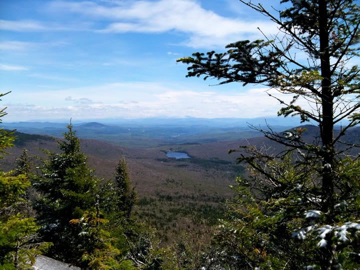 If you suffer from acrophobia (fear of heights), the fire tower at the summit probably isn't for you; then again, it's a great reason and opportunity to face your fears! Once atop the high platform of the tower, something deep inside begs to be let out, be it a "woohoo", a "yeehaw", or even just an "Oh my God." This image doesn't do the view justice, it is something you've got to experience for yourself to fully appreciate.
Another surprisingly enjoyable experience from this hike was the raised-rock pathway that serves as stepping stones through some wet areas. I rather enjoyed playing hopscotch along them, but when the stepping stones graduate into sheer exposed boulders, the sheer ice along some places forced me to tread more cautiously.
 There are a couple spurs on the right of the main trail, one of which I discovered is really just a bunch of moose footpaths. You can't get lost on this hike, unless you take one of these spurs...just stay on the obvious main trail and if you get curious, go wandering only on the way back. Trust me, the views at the summit are worth bypassing any other adventures until later!
Easy to moderate incline, 4.4 mi round trip, summit elevation 3037 ft.
Highlights:
360 degree views from the fire tower at the summit, caves and crevices galore, beaver pond, stone-raised trail bed.
Directions:
Heading east through Barre, take US 302 up the hill towards it's intersection with VT 110. Continue east on 302 about another mile and turn left onto Reservoir Road (which turns into Brook Road once it enters Plainfield). In nearly 5 miles, the pavement turns to dirt and you'll continue another 1.5 miles to a junction where you'll take the right onto East Hill Road. Keep going up the hill until reaching Spruce Mountain Road on the right. Follow Spruce Mtn. Road to the end, where obvious signs mark the trailhead and parking area. Details:
I am SO excited about this hike! By far my favorite, this trail offers everything that makes hiking fun: amazing views, various terrain, incredible flora and fauna lurking around every corner, and some special side-of-the-trail treasures - CAVES!
If you suffer from acrophobia (fear of heights), the fire tower at the summit probably isn't for you; then again, it's a great reason and opportunity to face your fears! Once atop the high platform of the tower, something deep inside begs to be let out, be it a "woohoo", a "yeehaw", or even just an "Oh my God." This image doesn't do the view justice, it is something you've got to experience for yourself to fully appreciate. Another surprisingly enjoyable experience from this hike was the raised-rock pathway that serves as stepping stones through some wet areas. I rather enjoyed playing hopscotch along them, but when the stepping stones graduate into sheer exposed boulders, the sheer ice along some places forced me to tread more cautiously.
There are a couple spurs on the right of the main trail, one of which I discovered is really just a bunch of moose footpaths. You can't get lost on this hike, unless you take one of these spurs...just stay on the obvious main trail and if you get curious, go wandering only on the way back. Trust me, the views at the summit are worth bypassing any other adventures until later!
Friday, May 7, 2010
Amity Pond Natural Area - Pomfret, Vermont
Quick Facts:
Easy to moderate incline, estimated 4 mi round trip, elevation 1340 ft
Highlights:
Pico views, open meadows, two shelters!
Directions:
From I-89, take exit 3 (Bethel/Royalton) and take a right onto 107 towards Bethel. At the junction of 12 and 107, take a left onto 12 under the railroad tracks and over the iron bridge. Travel about 2-3 miles until you see Locust Creek Diner on the left and it's sister gas station on the right. After the Diner, take the left onto 12 which continues south towards Barnard. Follow it until you come to the Barnard Country Store, and continue straight onto Stage Road, which is to the left of the store. You'll know you're on Stage road if you look to your left and see Silver Lake through the trees (There's also a sign about a block past the store on the right side of the road that finally declares the name of the road...oddly enough). About a mile later, you'll take a left onto Royalton Turnpike. Another mile later is Sayer road, which will be on the right, and will later turn into Lime Pond and/or Webster Hill Roads. Just stay on it until you reach Skyline Drive on the left. On Skyline, you'll pass through some beautiful horse properties, and then come upon Allen Hill Road, which you'll take a left onto. About 500 yards up on the right will be a red metal gate where you can park, and the Natural Area's entrance will be on the right.
Details:
The 182 acres of the Amity Pond Natural Area were a gift to Vermont from Richard and Elizabeth Brett in 1969. A downloadable pdf about the area (map and history included) is available here, although it's nearly impossible to get lost on these trails. The blue blazes clearly mark the obvious trails, and wherever you get close to private property or trail junctions, carved wood signs keep you on the right track. One thing to keep in mind, is that there is an electric fence at one end of the Amity Pond Trail, so keep the dogs leashed when you come upon the open pasture.
 Although you can take the road up to the other end of the Amity Pond trail (see pdf map), I decided to get a longer hike in by back tracking onto the trail and taking the Crossover Trail to the other side (the fact that the brook at the end of the southern side of the trail was a bit too wide to cross w/out my rubber boots helped make that decision for us). We started from the parking area on Allen Hill Road (which isn't as large as the map indicates) and hiked down to the too-wide-to-cross brook which runs along Broad Brook Road, then backtracked to the Crossover Trail and continued toward the horse pasture on Allen Hill Road. Once we hit the road, we backtracked again and took the Amity Pond loop, which gave us a total of about 4 miles. You get a break from the wooded area with this beautiful field where there are mountain views to admire.
 There are two shelters here, both with fire pits and near water sources. The Amity Pond Shelter is a little close to the road for me, and it also sits near a swap-like small pond, but the Sugar Arch Shelter is right in the heart of the woods and is set near a stream and a meadow, so I think staying at the latter is the best choice for optimal overnight camping.
 We never did find the Skyline trail...although I'm not sure if the dogs were even looking...much too busy playing with their sticks again!
Easy to moderate incline, estimated 4 mi round trip, elevation 1340 ft
Highlights:
Pico views, open meadows, two shelters!
Directions:
From I-89, take exit 3 (Bethel/Royalton) and take a right onto 107 towards Bethel. At the junction of 12 and 107, take a left onto 12 under the railroad tracks and over the iron bridge. Travel about 2-3 miles until you see Locust Creek Diner on the left and it's sister gas station on the right. After the Diner, take the left onto 12 which continues south towards Barnard. Follow it until you come to the Barnard Country Store, and continue straight onto Stage Road, which is to the left of the store. You'll know you're on Stage road if you look to your left and see Silver Lake through the trees (There's also a sign about a block past the store on the right side of the road that finally declares the name of the road...oddly enough). About a mile later, you'll take a left onto Royalton Turnpike. Another mile later is Sayer road, which will be on the right, and will later turn into Lime Pond and/or Webster Hill Roads. Just stay on it until you reach Skyline Drive on the left. On Skyline, you'll pass through some beautiful horse properties, and then come upon Allen Hill Road, which you'll take a left onto. About 500 yards up on the right will be a red metal gate where you can park, and the Natural Area's entrance will be on the right.
Details:
The 182 acres of the Amity Pond Natural Area were a gift to Vermont from Richard and Elizabeth Brett in 1969. A downloadable pdf about the area (map and history included) is available here, although it's nearly impossible to get lost on these trails. The blue blazes clearly mark the obvious trails, and wherever you get close to private property or trail junctions, carved wood signs keep you on the right track. One thing to keep in mind, is that there is an electric fence at one end of the Amity Pond Trail, so keep the dogs leashed when you come upon the open pasture.
Although you can take the road up to the other end of the Amity Pond trail (see pdf map), I decided to get a longer hike in by back tracking onto the trail and taking the Crossover Trail to the other side (the fact that the brook at the end of the southern side of the trail was a bit too wide to cross w/out my rubber boots helped make that decision for us). We started from the parking area on Allen Hill Road (which isn't as large as the map indicates) and hiked down to the too-wide-to-cross brook which runs along Broad Brook Road, then backtracked to the Crossover Trail and continued toward the horse pasture on Allen Hill Road. Once we hit the road, we backtracked again and took the Amity Pond loop, which gave us a total of about 4 miles. You get a break from the wooded area with this beautiful field where there are mountain views to admire. There are two shelters here, both with fire pits and near water sources. The Amity Pond Shelter is a little close to the road for me, and it also sits near a swap-like small pond, but the Sugar Arch Shelter is right in the heart of the woods and is set near a stream and a meadow, so I think staying at the latter is the best choice for optimal overnight camping.We never did find the Skyline trail...although I'm not sure if the dogs were even looking...much too busy playing with their sticks again!
Updates coming soon!
Okay, lots of hikes taken lately...some frustrating, some repeats, some easy, and some challenging. I can't wait to blog about it, but I've got to take another hike today first!
Look forward to the following:
L♥VERMONT!
Look forward to the following:
- Hanover, NH: Appalachian Trail - Velvet Rocks Section
- Three Stallion Inn Network - Randolph, VT
L♥VERMONT!
Subscribe to:
Posts (Atom)